
What to pack for Scottish Winter Climbing
08/11/2018
Crampon Guide | How to Choose
09/12/2019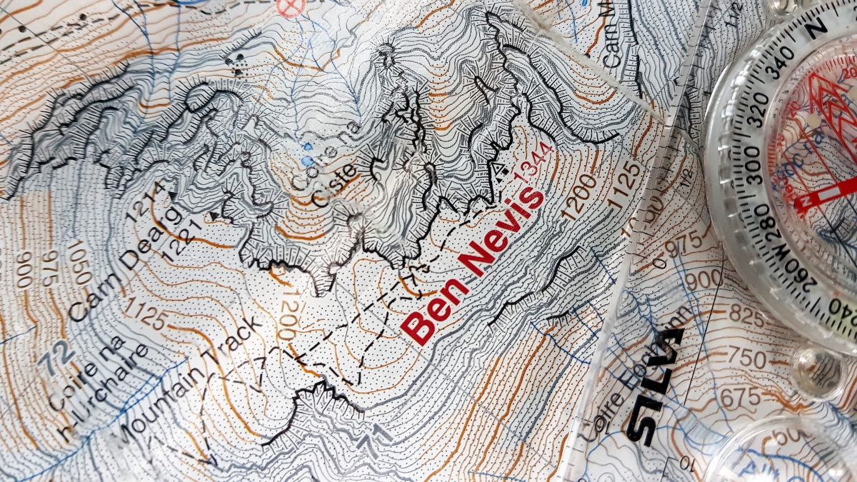
HOW TO NAVIGATE OFF BEN NEVIS SUMMIT
AUTHOR | STEVE HOLMES
The number of people climbing Ben Nevis each year is in the tens of thousands. With the increase in tourism and participation in outdoor sports, the numbers attempting to reach its summit are only set to increase. In this blog, I have tried to explain what I believe to be some of the defining factors in How to navigate off Ben Nevis summit.
Three important considerations before attempting to climb Ben Nevis would be;
What is the weather going to be like on the summit? Is everyone in your party fit enough to make it up AND down the mountain, and has everyone in the group got enough equipment and nutrition to keep themselves safe.
There are of course plenty more factors that need to be evaluated before heading up any mountain or hill. Yet I am going to touch on these three important questions as they can all directly lead to poor decisions and navigational errors on Ben Nevis.

What is the weather going to be like on the summit?
Temperature and weather conditions fluctuate at an alarming rate on the summit of Ben Nevis. It is not unknown for the temperature to drop and rise 10 degrees Celsius or more in less than 24 hours. So, when standing at the foot of the mountain in your t-shirt and shorts consider the fact that the summit could be single digits and for more than half the year, covered in snow.
We are incredibly fortunate to have accurate mountain weather forecasts at our fingertips. Taking the time to read them can be the difference between an enjoyable day or a very cold and potentially disastrous one. Something that I have learnt and preach to my clients is to always have a warm jacket. I do not anticipate getting into trouble or injured every time I go out in the hills, but there have been several occasions when I have come across other people in desperate need of assistance then spent hours waiting for help to arrive.
MWUK (Mountain Weather UK) is a really good app that costs around £4. The App feeds data from popular and generally reliable mountain weather resources such as MWIS and Met Office. But if you do not want to pay for the use of the App, look no further than the two simple websites below.
Mountain Weather Information Service – select Scottish Forecast – West Highlands for Ben Nevis area
Met Office Mountain Weather – select Southwest Highlands for Ben Nevis area

Is everyone in your party fit enough to make it up AND down the mountain?
Fitness is very subjective and almost always overlooked by casual hillwalkers aiming to climb Ben Nevis. Walking in an upwards motion for half a day is very hard to train for, so despite the marathon you ran last year, be ready for a shock to the system.
Bear in mind the start of Ben Nevis is barely above sea level so a slow and steady approach with efficient stops makes for good prior planning. The path is steep and approximately 10 miles up and down so too much dawdling can lead to benightment and added pressure should the conditions deteriorate. Consider using June and July with the longest daylight hours for your attempt, but also be aware that snow can linger above 1000 meters into August covering the cairns on the summit plateau and making the steeper sections slippery.
I would ask yourself is everyone in the party fit enough to make the top and get back down. Nobody wants to be the one holding friends and family back, yet I have witnessed parents having full-blown arguments in 60mph winds, 1000 meters up Ben Nevis about whether their struggling children will be OK to carry on or not. Summit fever as it is dubbed is as consequential for the motivating person as it is for someone who says nothing when they are clearly on their last legs. Getting to the top is only half the battle, getting back down is almost always as taxing or even more tiring for novice walkers.
Has everyone in the group got enough equipment and nutrition to keep themselves safe?
With so many cheaper options for buying good outdoor equipment, there really is no excuse for not being able to keep yourself reasonably dry and warm in the Scottish mountains. Both eBay and Facebook pages are ideal places to get bargains. I would sooner use a second-hand piece of branded clothing than a newer counterfeit that cost almost the same amount of money. Re-selling the equipment back on again after using it is an option if you decide mountain walking or climbing is not for you. In my experience it isn’t that people don’t have the correct equipment, it is the lack of understanding that conditions change so quickly on the UK’s highest mountain. We have already touched on the necessity to check mountain weather forecasts before setting out so don’t second guess the forecast just because its 16 degrees and blue skies in Glen Nevis.
Essential clothing for any time of year on Ben Nevis would be a warm synthetic jacket (down insulation is useless when wet), a fully taped waterproof jacket, a pair of full gloves or mitts and a hat or cap. Remember, you may not need it on that warm sunny day but come across a stricken walker or climber you could find yourself out on the mountain under nightfall.

Every person will need some sort of nutrition. How often is it that people who don’t regularly eat on a working day take that approach to the hills then feel exhausted the following day? I can fully understand that a ‘big breakfast’ can keep you going for most of the day but calories are being burnt at a steady rate going up or down. Take some favourite snack food and eat and drink little and often.
The three vital topics discussed can have an adverse effect on your ability to safely navigate off the summit of Ben Nevis. Not enough food and dehydration can lead to exhaustion and confusion, people who lack fitness are more likely to get injured or become benighted and poor preparation for adverse weather can lead to getting caught out high on the mountain.
Want to Climb Ben Nevis via Tower Ridge with a professional? Or maybe like to learn how to become a winter mountaineer so you can climb Ledge Route with your friends? Please get in touch for a no-obligation chat about how our friendly team can help.
The good news…
The majority of hillwalkers will attempt to climb Ben Nevis during the ‘summer’ months of July and August when typically the mountain path has only a few snow patches left obscuring its destination. Navigationally the path is pretty obvious especially in dry weather where thousands of footfalls have changed the colour of the rocks to a lighter shade. As you get higher the path is rougher and becomes uneven yet unless exhaustion is setting in it is very obvious which way to go and avoid potential hazards. The sheer amount of walkers many of which are being guided by local leaders and guides does give a good indication of the direction to travel yet always be aware that not everyone has the same destination and following others randomly can only lead to navigational errors.

However…
When snow is on the ground, the topography changes dramatically. Steep sections of the path above 1000 meters can become very slippery, the summit cairn is often buried in snow and the upper path is usually completely obscured from December to April. It is important to have some winter mountaineering skills during the winter months. Rain can camouflage the lighter colour of the path too and strong winds disorientate cold ill-equipped parties on the summit plateau.
In late 2009 work was completed on the line of stone cairns (think 6ft stone pyramid) that are an aid to both reaching and descending from the UK’s highest mountain. The newly erected stone markers replaced a maze of less obvious and smaller cairns that were once scattered over the plateau. Followed correctly the line of newer markers can lead you to the summit and back down again avoiding a potential fall down the very steep North face. They do however, stray from the main tourist path which is both flatter and easier when weather conditions are friendly. A level of common sense must be exercised on whether the markers are followed (maybe when conditions deteriorate) or to stick to the well-trodden path.


Navigation
Taking a map and compass is only advisable if you know how to use one. Synergy Guides can provide a Ben Nevis guide who can be used to teach the intricacies of navigation and map reading, but there are also many good books and online tutorials available. The trick is to practice somewhere safe where there is little in the way of steep cliffs or consequential ground.
The correct grid bearings from the trig point of Ben Nevis are 231 degrees for 150 meters then 282 degrees which takes you in line to intersect the main corners of the mountain path. Deviating from either bearing has its consequences so keep alert and concentrate. I can’t remember how many times I have been to the summit of Ben Nevis – but it is over a thousand. During the winter months, I still always have a map and compass in my pocket when I plan to leave the summit.
If you don’t know how to use a map and compass then there is little point in carrying one but another aid that I have to hand is my mobile phone and an application called ViewRanger.

ViewRanger is a free app which allows you to pay for individual maps depending on where you are in the world. It is quite cost-effective as Ben Nevis can be purchased for less than £1. When the ‘locate’ button is pressed the crosshairs will show you in red where you are on the map. As you walk a red arrow shows the direction of travel. I can’t stress enough, if you don’t know how to read a map then the app is useless as all the lines and details will mean nothing. It is however, a good tool to have alongside a map and compass should you drop or lose one, or the other.
Conclusion
If you have read this blog, you may have noticed I’ve spent less time on the ‘navigation’ section. Naturally, I believe it is important to have the required skill to navigate properly using a map and compass, yet I also believe it is a small part of the reason so many people get into trouble whilst ascending (and more often than not) descending from the summit of Ben Nevis.
Take time to assess and prepare your day. Learn how to decipher the mountain weather forecasts, really consider the whole parties fitness and ability to look after themselves and be confident that when the summit is finally reached you can cope with prevailing conditions and navigate safely back down again.
About the author
Steve Holmes owns Synergy Guides, he is a fully qualified Mountaineering Instructor and holds the WMCI (MIC) award. He spends most of his winter climbing on the white cliffs of Ben Nevis; a place he calls home. You can read more about him here.
